A fun little MapInfo update and working through the dissertation outline
This week started with a fun last-minute research trip with a lot of material I am still working through, but the rest of it has mostly been about trying to revise the dissertation outline into something coherent.
MapInfo archives and meeting a founder
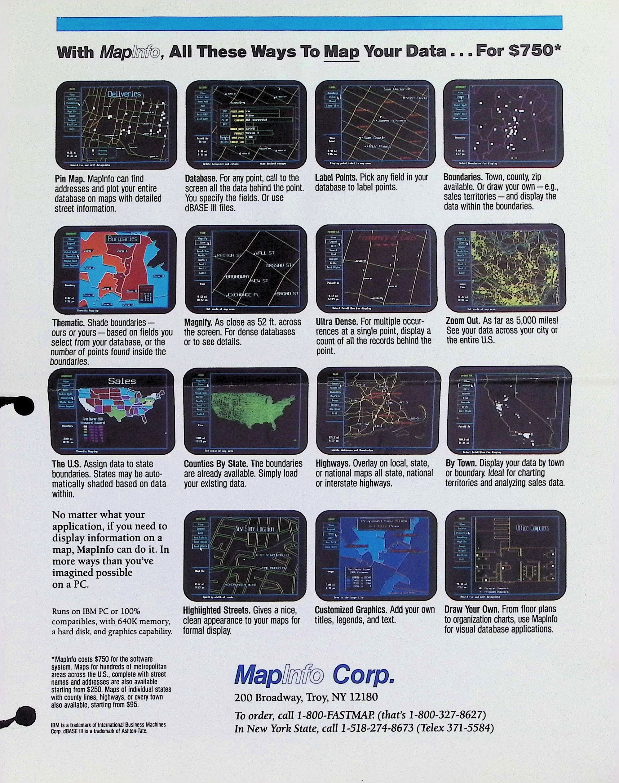
On Tuesday I was in Saratoga Springs, New York, meeting with John Haller, a co-founder of MapInfo. John was gracious enough to let me go through and scan his box of MapInfo papers, which went as far back as documentation of the routing software project that he and Sean O’Sullivan developed as RPI undergrads that became the basis for the company. He also had a few years’ worth of copies of Browser, MapInfo’s company newsletter, which have a ton of interesting little details within them. I’m not going to post too much of the stuff I scanned because 1) it’s got pictures of former MapInfo employees whose consent I don’t even know how to begin getting and 2) although I am guessing the “confidential” markings on some of those 1980s business plans are a little moot at this point, I also don’t especially want Precisely to suddenly be like “excuse me this is our IP” or something. But sharing the old sell sheet above probably won’t incur anyone’s IP wrath? Also please enjoy this
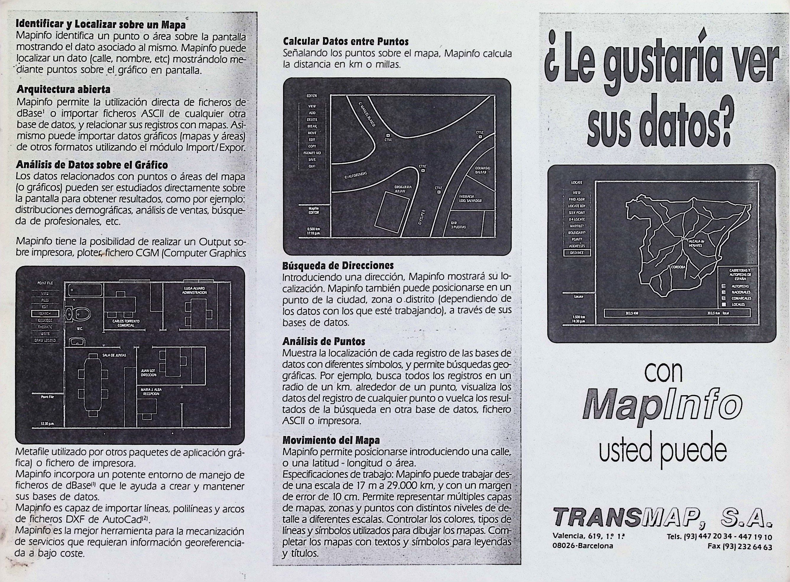
Spanish-language MapInfo promotional trifold:
Lots more to say, but a few things that really stood out talking to John and going through the documents:
The MapInfo founders basically knew nothing about GIS or even really basics of mapping when they got into building their product. Admittedly, they thought they were going to be a pre-GPS navigation company, so initially they thought their primary competition was Etak, but basically it was in going to trade shows and talking to investors that they learned that there was already a whole existing industry for this stuff. In contrast to Esri’s origin story among landscape architecture and planning or even Intergraph’s early work on missile guidance systems, it really was just some super-young guys who saw a technical challenge they thought they could meet. While this would seem to put them at a disadvantage in terms of lacking technical expertise, it also meant they assumed users who also weren’t experts which meant they made a product that was more appealing to basically everyone. (Reminder: ArcView was made in response to MapInfo, Esri made GUI map software basically in a panic over a competitor.) This non-user perspective ultimately became the company’s niche and a driving principle of their software design choices. (To me this is interesting as a distinction from Esri and arguably even Intergaph, which went to great lengths to position itself as the tool of experts—they were much more focused on constructing the user persona of the “GIS professional” than MapInfo.)
The MapInfo guys were so young when they started the company. In one of the investor prospectus documents, Haller included working at a country club concession stand in high school as an instance of past work experience as a manager—because he was 21 freaking years old and basically had worked maybe four jobs ever at that point. Granted, Jack Dangermond was 24 when he drove out to Redlands with Harvard Lab IP in the trunk of his car or whatever, but Esri didn’t actually really pursue being a product-based company until Dangermond was well into his 30s (if we take Scott Morehouse joining in 1981 to build what becomes ARC/INFO as sort of the moment that pivot really begins). I think Haller was honestly a little bit unsettled by my talking about stuff he did in his 20s as “history” when he’s maybe not even in his 60s yet.
Having started the company super-young may or may not have any bearing on this, but I think it’s very cool how many of the founders went off to do totally different things beyond MapInfo. Sean O’Sullivan’s kind of the only one who stayed “in” tech, albeit as a venture capitalist (also we have him apparently to thank/blame for the term “cloud computing”—some joke in here about the irony of a guy who made a bunch of money at a young age on software for mapping physical reality then inventing a term pilloried for its divorcing of computation from its material, physical conditions), but SOSV as far as venture firms go seems to make reasonably coherent and actually-making-stuff business bets (FormLabs, lithium battery recycling tech, other climate tech and biomaterials stuff that probably won’t be a 1000X return but hey, it beats all the socially corrosive shit A16Z and Thiel invest in). The rest of the founders went in totally different directions from software. Andrew Dressel became an academic focused on bicycle science and mechanics (extremely cool). Laszlo Bardos is a little harder to find up-to-date information on but Haller said last he’d heard Bardos had become a middle school teacher, which is very wholesome. As for Haller, he did a few more software company things after his time at MapInfo and made some good money, much of which he has since put towards running a really nice community woodworking space in Saratoga Springs. Like: honestly very wholesome outcomes, which thirty-plus years on is generally not the outcome for 20-year-olds who become stupid rich in a relatively short timeframe!
Revising the dissertation outline
So the original outline I proposed for this dissertation was made under both a time-sensitive duress and under psychological duress of finding out that the grant I was on had been overspent in such a way that I literally did not know how much funding and time I had left. This is to say: it was largely horseshit, and I suspect my committee only passed the proposal defense because of the duress of the situation. While I unfortunately remain under duress (the situation remains shitty, and my prospects in academia seem not so great given the whole “authoritarianism killing higher education as we know it” thing)
One problem is the multiple scales of narrative. Oral history interviews are about the singular experiences of individuals in historical contexts; they are opinionated and specific and most people don’t tell the story of their lived experiences in terms of world-historical context. At the same time, archival sources like trade journals and newspapers and softwares provide a bigger picture narrative.
Another problem of scale: on the one hand, there’s the story of geospatial software as industry—a story of markets and applications and finances. On the other, there’s the story within that story of specific methods or technologies that I want to call attention to. What’s the best way to organize these different narrative scales?
This has led to doing a bunch of color-coded index card arranging on the floor (because there isn’t enough wall space for a serial killer wall arrangement) and roughly, I’ve got three broad categories/industry sectors that lend themselves to chapters:
Inventing the GIS market: This focuses mostly on the 1980s-1990s period in which turnkey desktop computer mapping softwares became A Thing with a reasonably competitive market landscape that eventually came to be dominated by one company. Largely drawing on one wild interview with someone who was at Esri for like 30 years, interviewing John Haller, experiments with old software, and trade publications/archival media and some of the MapInfo documents mentioned above. Probably also will talk a little about Mike Liebhold’s proposed geospatial software projects within Apple in the Scully years that were kind of ahead of their time and didn’t really gain traction but are useful for thinking about some of the cultural zeitgeist stuff around maps and computing beyond the business/government space.
Navigation (before and after GPS):Unfortunately currently the thinnest section of my research because it is annoyingly hard to get people in that world to talk to me (this might be because this is one of the few areas where there’s actually money at stake?). Really coterminous with the “inventing GIS” era. The bifurcation between computer navigation and computer mapping/GIS is sort of the result of different intellectual lineages, with the former more coming out of operations research. I’ve had a little success talking to people on the consumer-product side of navigation stuff (i.e. people selling in-car hardware or making data products for in-car navigation) but less on the side of commercial or government uses (e.g. route design for garbage trucks or long-haul trucking). This might be for the same reason I kind of just decided the dissertation would be focused almost entirely on vector maps, which is that the remote sensing and satellite imagery industry makes too much money for anyone in it to actually be open to talking about itself with any real frankness. Navigation has a much more obvious “how do we make money” story, and I guess people who were part of that story don’t particularly want to talk about how they made all that money. As a result this section is mostly archival media interpretation, maybe threading into more contemporary last-mile logistics tech stuff (i.e. app-based delivery gig economy tech). It won’t be the best chapter but given how thin the academic literature seems to be on just a general “here’s a timeline of developments in computerized navigation methods in the public and private sector” it’s maybe worth doing?
The emergence of geo tech, or, everything everywhere all at once: Probably my strongest thread of research, recency bias and already knowing a lot of people in the scene helps. The academic term of art for this era/bucket of technologies tends to be “geoweb” but feel like within the scene it’s almost exclusively discussed as “geo.” It’s kind of more a story of phones than the internet—the internet is a big part of it, of course, but the shift from the internet as sequestered (i.e., desktop) experience to a mobile one plays a huge role in transformations to geospatial tech. It’s also where this bifurcation between navigation and mapping breaks down as they’re rendered part of one big geo stack. Have lots of interviews from people who were part of this moment, more on the open source side than the Google/proprietary side.
Within these, I’m thinking a bit about nonlinear asides that can go deeper on some of the people and key methods/tools. My interviewees’ experiences speak to this thing I was writing about a couple of weeks ago regarding the kinds of labor subjects produced by different geospatial softwares and companies—also like, a bunch of people were generous enough to be at times very vulnerable and candid with me about their lives and I want to honor that perspective while also situating it in broader context. Similarly, the fact that there are technical precursors to the map tile isn’t actually something I can wrest a full book chapter out of, but it is something that is worth explaining sort of as its own little thing.
The original research questions I used in the grant proposal for this project were What were the motivations and goals behind the development and funding of key geographic information system (GIS) tools? How do those original intentions shape their design? Initially I thought I’d be organizing myself around specific methods—the shapefile or the EPSG dataset or the map tile. The stories of those tools are still part of the dissertation, but aside from those just being really small stories I think it makes more sense to explain how computerized methods of analyzing, understanding, and traveling through space became niche, highly-government-dependent business sectors and how different methods emerged from those sectors.
I don’t know. Does this make sense? Does it matter if it makes sense? I have to keep reminding myself that the dissertation is really my first shot at telling this history and not my only shot.